20 May 2018 7:00 pm: Though there is currently some light rainfall over the Dayton, OH area, I think we're in the clear when it comes to significant thunderstorm development tonight. You may hear a rumble of thunder, but more than likely this is going to be due to heat lightning. In any case, play it conservative, because avoiding lightning strikes shouldn't be a game of odds. If you hear thunder, get yourself indoors... As for the overnight and the outlook tomorrow, I'll have to get back to you. I haven't run my codes this weekend until a few minutes ago, so it's difficult to say how the ground conditions are changing. At the moment there's a large high pressure system to the N / NW extending over us that coincides with a few regions of lower cloud formation, so large updrafts / thunderstorms should be limited. A lower pressure region looks to be extending from the gulf at this time, and if it continues to push N / NE throughout the evening / morning hours we should expect showers and potentially significant thunderstorms tomorrow. Keep an eye on that barometer reading from your local forecast office. If we start dropping to 30.00" or below, you should bank on a storm or two by the p.m. tomorrow.
15 May 2018 4:30 pm: Despite feeling sick and having to leave work early, I guess it worked out pretty well. We're finally breaking out of the lackluster thunderstorm forecasts that have been posted by the NWS since Friday evening. I'm admittedly in a likely small demographic of people who actually get excited when storms hit. In any case, I just put out a Thunderstorm Warning - This is unofficial, as I haven't been able to corroborate this with the NWS Wilmington office due to apparent internet problems on their end. However, multiple lightning strikes have been observed in the past minutes. Current radar has shown a small cell south of Dayton, OH and heavy rainfall is currently observed in Kettering, OH. Keep up to date with your local NWS forecast offices throughout the evening. I'm expecting more storms as the afternoon / evening progresses. With the low level IR cloud system that has been circulating the storms over Florida since Saturday dissipating, and the relative low pressure path extending over the midwest into SW Ohio, I'm expecting further storms throughout the evening with the added humidity from today. The data has been rather volatile (if not absolutely squirrelly) since Friday, so keep your eyes peeled on the forecast given by local meteorologists, because it's been pretty unpredictable on an hourly basis.
14 May 2018 8:45 pm: The storms currently across Missouri into Illinois look to be heading eastward with an increased consolidation / organization over the last hour per radar imagery. The relative pressures on approach to the SW Ohio area are low enough compared to surrounding regions to promote moderately sustained upward air movement. However, the relative humidities on this approach are fairly low, which makes me skeptical that this storm system will maintain it's intensity over the next several hours. That being said, I think the current overnight forecast for WPAFB has downgraded the potential for storms a bit prematurely. There's definitely still potential for scattered showers / thunderstorms tonight. However, at the current rate the storms are moving, I wouldn't expect to hear any rumbles of thunder until 3 am at the earliest. At that point, temperatures should have dropped substantially, so any storms are likely to be weak. In any case, with the storm systems dumping their rain along southern Illinois / Indiana, there should be a lot of humid air on approach to Dayton for storms to develop tomorrow if the pressures remain relatively low. I'm expecting the current low pressure region ahead of SW Ohio to actually expand tomorrow as the slow moving higher pressure system to the E / SE continues to move along. Given the high temperatures forecasted for tomorrow, with lower pressures and higher humidity we should expect to see moderate / isolated severe thunderstorms by mid-morning to early afternoon.
13 May 2018 4:45 pm: Apologies to anyone trying to use any weather info from this site over the past week. The laptop I have developed / run my codes on is temporarily out of commission while the motherboard is being repaired. Luckily I finally found some time to setup the programming tools I need on another computer. This is something that's been long overdue anyways, since this second computer was purchased largely for handling the eventual AI forecasting part of this project. In any case, as for today's weather, I'm a bit doubtful in any of this weekend's thunderstorm predictions proving accurate. The WPAFB thunderstorm forecast has been as high as 60% and 80% chances for the afternoon / evening respectively today. At present, those chances have dropped down to 40% and 30%, which seems pretty on point, but I wouldn't be surprised to see those forecast percentages drop again. A lot of the early morning humidity seems to have pushed NE since this morning, and there's only a narrow band of relative low-pressure through central Indiana and central Ohio. The current storms on radar are over a high-pressure region in NW Illinois, but appear to be heading slightly SE into lower pressure. If these storms continue to move into central Indiana, then there's a good chance of moderate thunderstorms into the late evening / overnight hours. Either way, I'd place better bets on tomorrow evening for stronger storms if the lower pressure region over Oklahoma, Kansas, and Missouri extends far enough eastward into the Great Lakes region.
3 May 2018 1:10 pm: The early line of storms that pushed through over the lunch hours appears to have broken up quite a bit and is moving on. This appears to be most likely due to the high pressure region to the south extending north since earlier this morning. As the temperatures increase for the dry portion of this afternoon, we could definitely see some moderate storm development into the evening if the pressures drop. From the satellite imagery, it looks like there's a nice channel of higher altitude cloud formation from N Texas through the central Great Lakes region, however, the highest clouds in Oklahoma / Kansas appear to have largely dissipated over the last few hours. If the high pressure region starts moving eastward we should see a lot more high cloud formation in the satellite imagery that would indicate stronger updrafts / storms. That being said, the current low pressure region of strongest storms still lies west of Missouri and the pressure distributions don't seem to be moving eastward very quickly. I'm placing my bets that the lowest pressure regions will not begin to move into the SW Ohio region until at least the overnight hours, at which point the temperatures won't be high enough to likely promote severe storm development. With the humidity left behind from today's rainfall, I'm guessing tomorrow is the better bet for more severe thunderstorms.
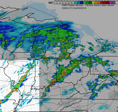
3 April 2018 8:25 pm: I have to be honest. I do not like what I'm seeing from my wind maps along this second line of storms. The region of rotation initially noticed along the central Illinois / Indiana border appears to be continuing into Indianapolis. This region of rotation has coincided with several tornado warnings so far. As last checked from the Indianapolis radar I did not see any tornado warnings, but I noticed that south of Indy had a relative drop in humidity, which indicates that less warm / moist air would be available for increased cloud development (and subsequently less "well-maintained" storm fronts). Currently, the humidity picks up again after Indy and the high temperature air from the south has been maintained. I suspect that this line of storms will exhibit increased severity after passing Indy. If these conditions are maintained and if the previously mentioned region of rotation continues to move eastward, I would not be surprised to see tornado warnings around Richmond, IN and Preble county, OH within the next 1-1.5 hours... All of that said, consult first your local NWS forecast office and local meteorologists for authoritative forecasting. This project is strictly educational in nature, so even I defer to the professionals when it comes to serious weather situations like those we are experiencing tonight.
15 May 2018 4:30 pm: Despite feeling sick and having to leave work early, I guess it worked out pretty well. We're finally breaking out of the lackluster thunderstorm forecasts that have been posted by the NWS since Friday evening. I'm admittedly in a likely small demographic of people who actually get excited when storms hit. In any case, I just put out a Thunderstorm Warning - This is unofficial, as I haven't been able to corroborate this with the NWS Wilmington office due to apparent internet problems on their end. However, multiple lightning strikes have been observed in the past minutes. Current radar has shown a small cell south of Dayton, OH and heavy rainfall is currently observed in Kettering, OH. Keep up to date with your local NWS forecast offices throughout the evening. I'm expecting more storms as the afternoon / evening progresses. With the low level IR cloud system that has been circulating the storms over Florida since Saturday dissipating, and the relative low pressure path extending over the midwest into SW Ohio, I'm expecting further storms throughout the evening with the added humidity from today. The data has been rather volatile (if not absolutely squirrelly) since Friday, so keep your eyes peeled on the forecast given by local meteorologists, because it's been pretty unpredictable on an hourly basis.
14 May 2018 8:45 pm: The storms currently across Missouri into Illinois look to be heading eastward with an increased consolidation / organization over the last hour per radar imagery. The relative pressures on approach to the SW Ohio area are low enough compared to surrounding regions to promote moderately sustained upward air movement. However, the relative humidities on this approach are fairly low, which makes me skeptical that this storm system will maintain it's intensity over the next several hours. That being said, I think the current overnight forecast for WPAFB has downgraded the potential for storms a bit prematurely. There's definitely still potential for scattered showers / thunderstorms tonight. However, at the current rate the storms are moving, I wouldn't expect to hear any rumbles of thunder until 3 am at the earliest. At that point, temperatures should have dropped substantially, so any storms are likely to be weak. In any case, with the storm systems dumping their rain along southern Illinois / Indiana, there should be a lot of humid air on approach to Dayton for storms to develop tomorrow if the pressures remain relatively low. I'm expecting the current low pressure region ahead of SW Ohio to actually expand tomorrow as the slow moving higher pressure system to the E / SE continues to move along. Given the high temperatures forecasted for tomorrow, with lower pressures and higher humidity we should expect to see moderate / isolated severe thunderstorms by mid-morning to early afternoon.
13 May 2018 4:45 pm: Apologies to anyone trying to use any weather info from this site over the past week. The laptop I have developed / run my codes on is temporarily out of commission while the motherboard is being repaired. Luckily I finally found some time to setup the programming tools I need on another computer. This is something that's been long overdue anyways, since this second computer was purchased largely for handling the eventual AI forecasting part of this project. In any case, as for today's weather, I'm a bit doubtful in any of this weekend's thunderstorm predictions proving accurate. The WPAFB thunderstorm forecast has been as high as 60% and 80% chances for the afternoon / evening respectively today. At present, those chances have dropped down to 40% and 30%, which seems pretty on point, but I wouldn't be surprised to see those forecast percentages drop again. A lot of the early morning humidity seems to have pushed NE since this morning, and there's only a narrow band of relative low-pressure through central Indiana and central Ohio. The current storms on radar are over a high-pressure region in NW Illinois, but appear to be heading slightly SE into lower pressure. If these storms continue to move into central Indiana, then there's a good chance of moderate thunderstorms into the late evening / overnight hours. Either way, I'd place better bets on tomorrow evening for stronger storms if the lower pressure region over Oklahoma, Kansas, and Missouri extends far enough eastward into the Great Lakes region.
3 May 2018 1:10 pm: The early line of storms that pushed through over the lunch hours appears to have broken up quite a bit and is moving on. This appears to be most likely due to the high pressure region to the south extending north since earlier this morning. As the temperatures increase for the dry portion of this afternoon, we could definitely see some moderate storm development into the evening if the pressures drop. From the satellite imagery, it looks like there's a nice channel of higher altitude cloud formation from N Texas through the central Great Lakes region, however, the highest clouds in Oklahoma / Kansas appear to have largely dissipated over the last few hours. If the high pressure region starts moving eastward we should see a lot more high cloud formation in the satellite imagery that would indicate stronger updrafts / storms. That being said, the current low pressure region of strongest storms still lies west of Missouri and the pressure distributions don't seem to be moving eastward very quickly. I'm placing my bets that the lowest pressure regions will not begin to move into the SW Ohio region until at least the overnight hours, at which point the temperatures won't be high enough to likely promote severe storm development. With the humidity left behind from today's rainfall, I'm guessing tomorrow is the better bet for more severe thunderstorms.
3 April 2018 8:25 pm: I have to be honest. I do not like what I'm seeing from my wind maps along this second line of storms. The region of rotation initially noticed along the central Illinois / Indiana border appears to be continuing into Indianapolis. This region of rotation has coincided with several tornado warnings so far. As last checked from the Indianapolis radar I did not see any tornado warnings, but I noticed that south of Indy had a relative drop in humidity, which indicates that less warm / moist air would be available for increased cloud development (and subsequently less "well-maintained" storm fronts). Currently, the humidity picks up again after Indy and the high temperature air from the south has been maintained. I suspect that this line of storms will exhibit increased severity after passing Indy. If these conditions are maintained and if the previously mentioned region of rotation continues to move eastward, I would not be surprised to see tornado warnings around Richmond, IN and Preble county, OH within the next 1-1.5 hours... All of that said, consult first your local NWS forecast office and local meteorologists for authoritative forecasting. This project is strictly educational in nature, so even I defer to the professionals when it comes to serious weather situations like those we are experiencing tonight.
|
|
3 April 2018 6:46 pm: I am keeping a very close watch on this second line of storms. If temperatures do not drop too quickly before the cold front moves in, I think there's a good chance that this second batch could be more severe than the first. I've been watching my wind maps closely and spotted an interesting region of overall rotation across the central Illinois / Indiana border. As I suspected, this coincided with storm velocity measurements from doppler radar in this region associated with tornado warnings. I will be keeping my eyes on any rotations such as this to identify regions that will require further assessment toward potential indication of increasingly favorable conditions for tornado development.
|
3 April 2018 5:35 pm: The tornado warnings previously issued by the NWS appear to have been downgraded to tornado watches for Greene county and Madison county at least as far east as London, OH. That being said, I didn't see the main forecast page for the Wilmington office reflect this update, so I'd take a conservative approach and heed the warning until the original 6:00 pm expiration. In any case, I think the initial round for the Dayton area is letting up, but I would keep a heavy eye on the band of storms currently in Illinois that I have highlighted in the image to the left. As this band approaches through the evening, I would expect the radar indications to continue exhibiting increased storm development as they approach the low pressure region sitting over us. These storms could be quite severe with a strong warm front to our south and a strong cold front coming in from the NW.
3 April 2018 5:07 pm: A tornado has been sighted by a local law enforcement spotter just south of South Charleston near State Route 42.
3 April 2018 4:45 pm: The NWS forecast office in Wilmington has just issued a tornado warning for NW Fayette, SE Clark, Central Greene, and SW Madison counties.
3 April 2018 4:24 pm: The local news has just indicated that the tornado warning for Montgomery county is expiring and the NWS forecast page for WPAFB has just moved the advisory back down to a tornado watch with a flood warning. We're definitely not out of the woods yet though. You definitely need to keep an eye on these storms for the rest of the evening. Due to the high humidity here and to our SW along with higher temperatures and low pressures, thunderstorms may develop much more quickly than you might expect. The radar maps have been quite volatile over the past couple of hours, so just because you don't see a band of storms approaching through Indiana / Kentucky at one moment, you may see a strong line begin to develop only minutes later on the radar. As I continue to take care of some basement flooding and keep an eye out for my own safety I'll do my best to issue some more updates as the evening progresses. That being said, keep an eye / ear to the local meteorologists and local NWS forecast offices. I highly encourage anyone in the SW Ohio / Miami Valley area to visit the website for the NWS Forecast Office in Wilmington. Stay safe out there folks.
31 March 2018 3:31 pm: My apologies to anyone who has visited this site looking for weather updates. I've been pretty absent from weather analysis over these past couple of days since I determined that the local meteorologists' / NWS forecasts have been pretty much foolproof since Thursday morning. Given that assuredness in the forecasts, I've been spending the bit of free time after my day job trying to further improve some of my artificial intelligence codes rather than follow the current conditions. Such is the predicament of a project under continuous heavy R&D... In any case, the NWS isn't giving more than a 50% chance of precipitation for Dayton until about 1:00 am. That looks pretty darn on point from what I'm looking at right now. There's been a good bit of rainfall to the NE over Michigan, but what looks to be of the most concern for the Dayton, OH region is the rainfall currently over southern Illinois and Indiana. Given the extra humidity left behind from these storms and the amount of time remaining before sunset today (this will give prolonged relatively high temperatures compared to more northern regions), I would suspect that the lower pressure region extending from Texas should lead to higher cloud development to the SW as the evening progresses. As temperatures cool into the night I would expect the low pressure region to extend eastward over the Dayton, OH region, which will promote continued cloud formation and subsequent moderate precipitation overnight. The precipitation should be relatively short lived though. The low pressure region to our W / SW is fairly narrow, and a large higher pressure region lies farther to the west. As the higher pressure region follows tomorrow it is likely that cloud formation will be limited and precipitation rates should become negligible by at least 11:00 am.
27 March 2018 7:53 pm: It looks like my general forecast for the Dayton, OH area yesterday was pretty darn accurate. The overnight (11:00 pm - 7:00 am) precipitation at WPAFB was less than 0.10 inches, which was in line with my prediction that we wouldn't expect to receive any rainfall beyond that amount. Furthermore, yesterday's prediction that the rain would steadily increase throughout today has generally been shown to be correct. However, I think we have reached a plateau in the rate of rainfall for the evening. The local pressure measurements from WPAFB haven't moved since about 4:00 pm, so the relative low pressure region from the SW doesn't seem to be expanding very quickly. As the temperatures begin to fall tonight I would expect the pressure changes to likely slow down in relation to regions west of Dayton, OH. That being said, I would put my money on the current rate of rainfall to remain relatively constant throughout the night. Tomorrow I would expect that the rate of rainfall will decrease by morning with cooler temperatures increasing overnight. Unless the low pressure region from the SW extends farther NE, I do not expect rainfall rates to increase throughout the day tomorrow. On the contrary, I would expect the higher pressure regions to the W / NW to move eastward and limit precipitation as the day progresses.
26 March 2018 10:27 pm: From the looks of things at the moment, I think the Dayton, OH area is in for some light rain tonight. Perhaps this "light rain" may be more of a mist. We're in a relatively moderate-high pressure region tonight, and as the temperatures fall (given the low 44% humidity right now) I would suspect that we shouldn't expect much more than a tenth of an inch of precipitation tonight. This pretty much agrees with the current NWS prediction for WPAFB of between 0.10 and 0.25 possible inches of precipitation overnight. That being said, as the low pressure region from the SW extends eastward tomorrow it will likely bring some of the humidity from today's westward rainfall over us. Given higher temperatures after the morning hours we could definitely see significant cloud formation and subsequent rainfall increasing as the day progresses.
22 March 2018 10:17 pm: I've heard multiple people today mention the idea that the Dayton, OH area is going to receive multiple inches of snow on Saturday. I'm not sure at all where this is coming from. The NWS forecasts for WPAFB are currently only predicting less than a half inch of precipitation (rain and snow) for Saturday. Though my primary concern is with short range forecasts (less than 5 hours), from what I've seen from my maps so far, I would be surprised if we get more than a quarter inch of snow. It looks like a low pressure front may be pushing up from the central plains, but there's not a ton of humidity ahead of that front to provide much moisture lift for heavy cloud formation. Moreover, the low pressure region also generally coincides with a higher temperature region. Though my maps do not extend too far to the west, I'm guessing a nice pocket of high temperature and low pressure air is coming up from Texas / Arizona / New Mexico (and farther south) that will drive some moderate storm development from the minimal humidity upon approach to the SW Ohio region. That being said, I think the precipitation for Saturday will be primarily dominated by rain rather than snow... At this point, I'm starting to give credence to a minor conspiracy theory that grocery stores are promoting fake news weather forecasts on social media to drive up massive buys of toilet paper, eggs, milk, and other general essentials. As ridiculous as that sounds, I can't think of a more logical reason why several people from several different circles would somehow believe we are about to experience an early spring snowmageddon this weekend. Either way, drive cautiously because I think most municipalities are trying to wind down their salt use at this point in the season, so even a bit of rain with a little snow could cause a few slick spots, especially across bridges and overpasses.
6 March 2018 9:46 pm: Not much of an update on the local weather other than that I'd expect some light rain / snow overnight. We're definitely in an isolated low pressure region and we seem to be pulling cold, humid air out of the NW Great Lakes region, so the snow is more likely as temps continue to drop overnight. However, I have added about 20 more overdue weather stations throughout the Southeast. I'm banking on the increased resolution of weather stations giving me a better picture to give more educated predictions regarding overall storm development probability. There are still so many more weather stations to add outside of Ohio, Indiana, and Kentucky on top of finishing the deep neural network codes. I'll take the small improvements tonight as a win in any case.
2 March 2018 7:26 pm: As it can most likely be seen this site is very much a sporadic, experimental work in progress. I already have created MATLAB codes that will construct single layer neural networks with limitless inputs, hidden neurons, and outputs. However, I am near completion of similar codes that will extend relevant capabilities to deep neural networks. Until that time, many of the updates on this site will be fairly behind schedule unless significant rainfall is forecasted by the NWS for the SW Ohio, SE Indiana, and NW Kentucky area. Despite the delays due to website development overhead, I think it's interesting to point out the amount of rainfall that was seen 27-28 February down south. My codes were definitely on spot for indicating potential rainstorm development in the Dayton, OH and tri-state region (the most concentrated gathering of weather stations I'm currently pulling from). However, the maps were not indicating heavy rainfall in the south / southeast. I attribute this to the lack of data collected. In most of the states east and southeast of Ohio I am only pulling data from one weather station compared to 25+ in Ohio. Without this additional concentration of data it becomes increasingly difficult to make basic inferences regarding storm development based on rudimentary principles of fluid, heat, and mass transfer. That being said, I have confirmed an expected, and obvious need for expanding the spatial concentration of data collection before researching the optimal deep network size that will provide the best near-term forecast adjustments in the Ohio / Indiana / Kentucky region... Also, from what the NWS is forecasting and from what I can see on my end currently, this appears to be a dry and moderately brisk weekend ahead. Enjoy some sunshine with the high pressure over the region.
28 February 2018 12:20 pm: Yesterday's low pressure system centered around Iowa, Kansas, Nebraska, and Oklahoma appears to have been encroached upon by a high pressure system out of the north. At present, the low pressure system appears to be mainly centered around Kansas, Oklahoma, western Missouri, and southern Iowa. The NWS is currently giving a 20% chance of rain for the Dayton area this afternoon with a 70% chance of showers after 2am tonight. This seems to be pretty on point if you ask me. Currently, the CONUS radar mosaic is showing dissipation of storms in Kentucky without much northward storm formation. Though we're sitting at 29.92" of mercury (usually that's low enough for storm development given the right temperature / humidity), the overall pressure distribution indicates that we're still only moderate with respect to surrounding regions. Assuming the aforementioned low pressure system and the costal high pressure system continue to move eastward throughout the afternoon and evening I'd place my bets on moderate showers late this evening with minimal chance of thunderstorms as temperatures fall overnight.
13 June 2017 11:05 pm: Today's earlier afternoon forecasts were a bust. After initial moderate morning / early afternoon rain the temperature and pressure never reached levels for high probability of severe thunderstorms. As pointed out in the previous statement, severe storms were not to be expected if the pressure did not fall below 29.95". In fact, the pressure never fell below 30.00". From my experience, for the Dayton area 30.00" is basically the demarcation line between potential storms and a relatively clear day. The lower you go from 30.00", the more likely you are to see significant thunderstorm development if the humidity and temperature are right. In any case, I think the addition of light rain on top of already high humidity in the presence of low wind speeds will provide plenty of moisture for evaporation to the upper atmosphere tomorrow. In my opinion, if ground atmospheric pressure falls below 29.97" and the temperature rises past 78 degrees (highly likely) we could see some significant thunderstorms. That being said, we could see some morning showers tomorrow. Depending on how fast we heat up as the day progresses we could see extra morning precipitation, which will further enhance the severity of storm formation in southeast Indiana and southwest Ohio.
13 June 2017: Confirming forecasts from the NWS in Wilmington, OH calling for an 80% chance of heavy rain for the Dayton, OH region. My personal observations seem to suggest that the atmospheric pressure will gradually decrease between Columbus, IN and Dayton, OH as the afternoon progresses. This should allow more upper atmospheric moisture to form, which will likely lead to heavy rain and possibly severe thunderstorms as ground temperatures begin to rise. The heaviest storms are estimated to arrive no earlier than 5:30pm, but will most likely arrive past 6:30pm. Strong thunderstorms should not be expected if the atmospheric pressure does not fall below 29.95".